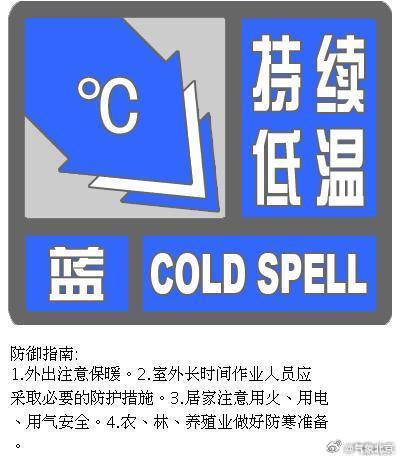
CCTV News: According to China Weather Network, today (February 6), the first cold wave of the Year of the Snake will be launched, which will bring strong winds and cooling weather to the central and eastern regions from north to south. The cooling amplitude of the process in the eastern part of the northwest region, North China and some areas of the Huanghuai region will reach more than 10℃. The gusts of wind and cold in the middle and lower reaches of the Yangtze River and the northeastern regions can reach level 7 to 8, and the wind-cold effect will be obvious. At the same time, there will be frequent precipitation in the eastern part of the southwest region, Jiangnan and other places today and tomorrow. It is the return period of the Spring Festival travel rush. The public should pay attention to preventing the adverse effects of slippery roads and reduced visibility on traffic.
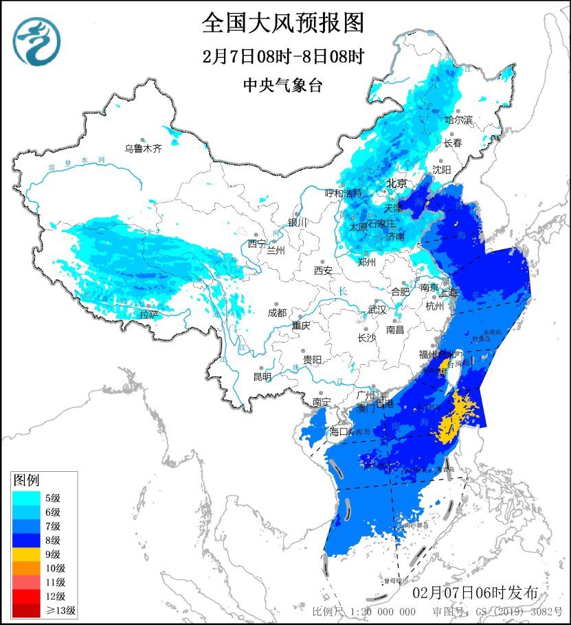
The cold wave begins today and the cooling is reduced by strong winds. The wind-cold effect is obvious in many places in the north. Since the beginning of the Spring Festival, cold air has become active. Starting today, the first cold wave in the Year of the Snake will affect the central and eastern regions from north to south, and bring strong winds and cooling weather. The Central Meteorological Observatory predicts that most parts of the Huanghuai River and its north will cool by 6 to 8℃, among which the cooling amplitude in the eastern part of the northwest, North China and Huanghuai River will cool by more than 10℃, most parts of the south will cool by 4 to 6℃, and some areas will cool by 7 to 8℃, and some areas will have strong winds of level 4 to 6, with gusts of level 7 to 8, among which some parts of the North China will gust level 9 to 10.
From the cooling process, today the cold wave will take the lead in affecting the Inner Mongolia area, and the local cooling amplitude in central Inner Mongolia can reach about 10℃. In the next two days, the central and eastern regions will enter a period of main impact on cooling.
Among them, the low temperature in the north generally occurs tomorrow, and the southernmost end of the highest temperature 0℃ line will reach the Huaihe River. North China and the Huanghuai River will become the core areas for cooling. The maximum temperature drop in some areas may reach about 10℃, and the chill is escalating.
For the southern region, the temperature low mainly occurs on the 8th, when the maximum temperature 10℃ line will quickly retreat south to the southern part of the Yangtze River. The maximum temperature in many places in the middle and lower reaches of the Yangtze River is less than 5℃. The temperature in Hefei, Wuhan, Nanjing, Shanghai, Hangzhou, Nanchang and other places will be significantly lower than the same period of the year.
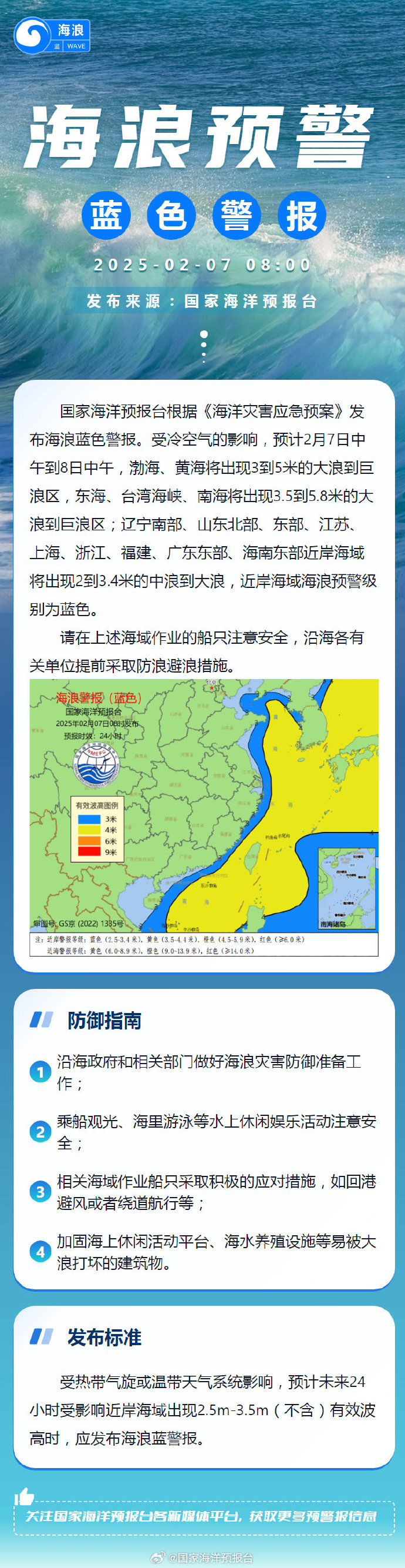
It should be noted that this cold wave will also bring continuous strong winds to many places in the north. Among them, the wind will be very strong today and tomorrow. The gusts of Beijing, Tianjin, Hebei, Shandong and other places may reach level 8 to 9. Coupled with the impact of cooling, the local wind and cold effect is significant. It is currently the peak period of travel and travel. It is recommended that the public take measures to prevent wind and cold when going out, stay away from temporary buildings, billboards, etc., and beware of falling objects from high altitudes.
The development of precipitation in the south increases, and snowfall in the northeast and other places
Affected by the enhanced warm and humid airflow, there was a round of weak precipitation in the south yesterday, mainly in the eastern area of the southwest region, and light rain occurred in eastern Sichuan, Guizhou, western Guangxi and other places.
Today is the day with the widest impact of this round of precipitation process in the south. Light rain will generally occur from the eastern part of the southwest to most parts of the south-south south, and the precipitation will shrink to the southwest tomorrow. In the north, there is not much snowfall today and tomorrow, and it mainly occurs in Northeast China, northern North China and Shandong Peninsula.
The Central Meteorological Observatory predicts that today, light snow or sleet will be found in some areas of central and eastern Inner Mongolia, northeastern region, northern Shandong Peninsula, eastern western Sichuan Plateau, southern Xinjiang Southern Xinjiang Basin, eastern Tibet, western Qinghai, etc., among which moderate to heavy snow will be found in some areas of northeastern Heilongjiang and eastern Tibet; light to moderate rain will be found in some areas of the southwest region, western and southern Jiangnan, central and northern South China, southeast Tibet, and eastern Taiwan Island.
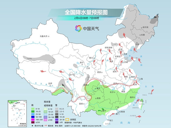
Tomorrow, there will be light to moderate snow or sleet in some areas of northeastern Inner Mongolia, central and southern Heilongjiang, Jilin, northeastern Shandong Peninsula, eastern Tibet, central and northern western Sichuan Plateau, central and northern Guizhou, among which there will be heavy snow in some areas of eastern Tibet and northern western Sichuan Plateau; there will be light rain in some areas of southern Hunan, Sichuan Basin, southern Guizhou, eastern Yunnan, Guangxi, eastern Taiwan Island, and moderate rain in some areas of southeastern Tibet.
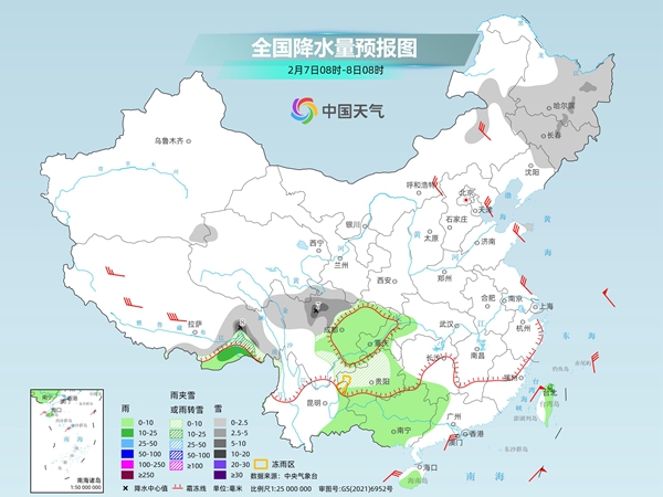
The meteorological department reminds that as the temperature gradually drops today and tomorrow, some areas of Guizhou, southwestern Hubei, northern Hunan and other places may experience sleeting, and local areas of Guizhou will be freezing rain. It is still in the return period of the Spring Festival travel rush. The public should pay attention to preventing the adverse effects of slippery roads and reduced visibility on transportation.